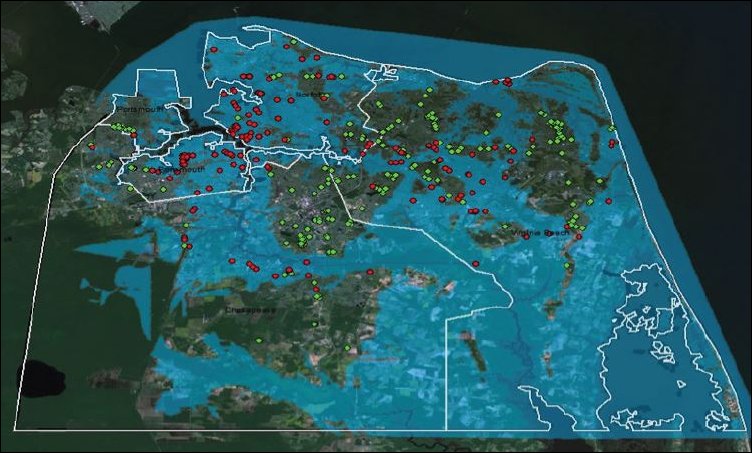
Flood-prone areas of south Hampton Roads. Source: Virginiaplaces.org. (Click for detail.)
One more takeaway from the Resilient Virginia launch conference yesterday: All other things being equal, more compact communities are more resilient communities.
Like Bacon’s Rebellion, Cooper Martin, program director of the Sustainable Cities Institute, is a big fan of Joe Minicozzi and his maps and graphics showing how dramatically land value-per-acre varies between core urban areas, suburbs and the countryside. Densely settled urban cores have land values that are literally a hundred times higher per acre than low-density shopping centers and large-lot subdivisions.
In my commentary, I have focused mainly upon the fiscal folly of building disconnected, low-density development. The infrastructure — the roads, utilities, sidewalks and other amenities — are more expensive per household to maintain. But Martin added a new dimension when addressing the Resilient Virginia conference yesterday. Low-density development makes it more expensive to harden homes and businesses against disruption and catastrophe. When the taxable value of land is high, it’s easier to support expensive investments to protect that land than when the value of the land is low. Continue reading
 by James A. Bacon The key to building a strong resiliency movement — making communities more adaptable in the face of natural and man-made disasters — is finding common ground. So argued Steven McNulty, director of the U.S. Department of Agriculture Southeast Regional Climate Hub, in addressing the launch event of Resilient Virginia this morning. Fear of rising temperatures, droughts and sea-level rise is a major impetus behind the increasing emphasis that all levels of government are placing on resiliency. But political views about climate change are highly polarized, McNulty said. “Are you a fear monger, or are you a denier? We need to get beyond that.” Most climate scientists believe that man-made climate change is a cause for concern. But the forestry land managers McNulty deals with do not. In a recent survey, he said, “only 10% of Southeast foresters thought that climate change is man-made and real. The agricultural community is almost as disbelieving.” As it happens, their perceptions are not without basis, he added. Rising temperatures in the Southeastern U.S. have been far less pronounced than anywhere else in the country.